
Moignelée topographic map
Interactive map
Click on the map to display elevation.
About this map
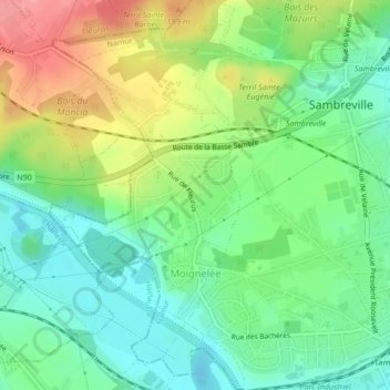
Name: Moignelée topographic map, elevation, terrain.
Location: Moignelée, Sambreville, Namur, Wallonia, Belgium (50.43161 4.57269 50.45479 4.59341)
Average elevation: 400 ft
Minimum elevation: 279 ft
Maximum elevation: 600 ft
Other topographic maps
Click on a map to view its topography, its elevation and its terrain.
Falisolle
Belgium > Namur > Namur > Sambreville
Falisolle, Sambreville, Namur, Wallonia, Belgium
Average elevation: 469 ft