
Lake Nemrut topographic map
Interactive map
Click on the map to display elevation.
About this map
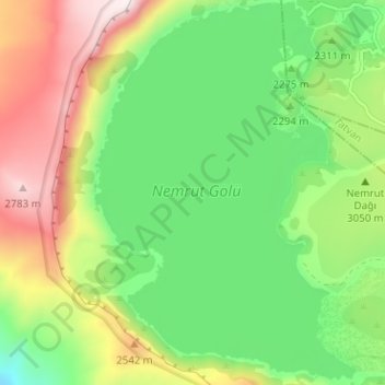
Name: Lake Nemrut topographic map, elevation, terrain.
Location: Lake Nemrut, Güroymak, Bitlis, Eastern Anatolia Region, Turkey (38.59702 42.20210 38.64583 42.24834)
Average elevation: 7,700 ft
Minimum elevation: 6,752 ft
Maximum elevation: 9,272 ft
Lake Nemrut is situated at an elevation of about 2,247 m (7,372 ft) above main sea level. It has an area of 12.36 km2 (4.77 sq mi), and its average depth is about 100 m (330 ft) with a maximum depth of 176 m (577 ft).