
Santa Rosa topographic map
Interactive map
Click on the map to display elevation.
About this map
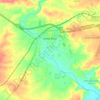
Name: Santa Rosa topographic map, elevation, terrain.
Location: Santa Rosa, Guadalupe County, New Mexico, United States (34.90537 -104.71476 34.95589 -104.62953)
Average elevation: 4,672 ft
Minimum elevation: 4,495 ft
Maximum elevation: 4,898 ft
Other topographic maps
Click on a map to view its topography, its elevation and its terrain.
Tejon
United States > New Mexico > Guadalupe County
Tejon, Guadalupe County, New Mexico, United States
Average elevation: 6,106 ft
Cuervo
United States > New Mexico > Guadalupe County
Cuervo, Guadalupe County, New Mexico, United States
Average elevation: 4,928 ft
Santa Rosa Lake State Park
United States > New Mexico > Guadalupe County
Santa Rosa Lake State Park, Guadalupe County, New Mexico, United States
Average elevation: 4,806 ft
Vaughn
United States > New Mexico > Guadalupe County
Vaughn, Guadalupe County, New Mexico, 88353, United States
Average elevation: 5,958 ft