
Abhar County topographic map
Interactive map
Click on the map to display elevation.
About this map
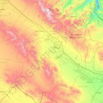
Name: Abhar County topographic map, elevation, terrain.
Location: Abhar County, Zanjan Province, 45618-95359, Iran (35.86552 48.84500 36.48912 49.43367)
Average elevation: 5,994 ft
Minimum elevation: 2,946 ft
Maximum elevation: 9,633 ft
Other topographic maps
Click on a map to view its topography, its elevation and its terrain.
Zanjan
Iran > Zanjan Province > Zanjan
Zanjan, بخش مرکزی, Zanjan Province, 45136, Iran
Average elevation: 6,155 ft