
Begur topographic map
Interactive map
Click on the map to display elevation.
About this map
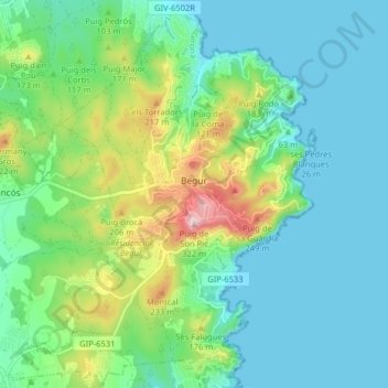
Name: Begur topographic map, elevation, terrain.
Location: Begur, Lower Empordà, Girona, Catalonia, 17213, Spain (41.92231 3.15527 41.98173 3.23404)
Average elevation: 253 ft
Minimum elevation: -3 ft
Maximum elevation: 1,020 ft
Other topographic maps
Click on a map to view its topography, its elevation and its terrain.
Palamós
Spain > Catalonia > Lower Empordà
Palamós, Lower Empordà, Girona, 17230, Spain
Average elevation: 177 ft