
Chandel topographic map
Interactive map
Click on the map to display elevation.
About this map
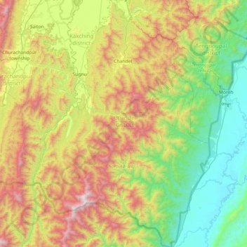
Name: Chandel topographic map, elevation, terrain.
Location: Chandel, Manipur, 795127, India (23.83362 93.73925 24.49251 94.25538)
Average elevation: 2,822 ft
Minimum elevation: 404 ft
Maximum elevation: 7,651 ft
Other topographic maps
Click on a map to view its topography, its elevation and its terrain.
Tengnoupal
India > Manipur > Tengnoupal tehsil
Tengnoupal, Tengnoupal tehsil, Tengnoupal District, Manipur, India
Average elevation: 4,003 ft
Loktak Lake
India > Manipur > Bishnupur > Thanga
Loktak Lake, Thanga, Bishnupur, Manipur, India
Average elevation: 2,533 ft
Imphal
India > Manipur > Lamphelpat
Imphal, Lamphelpat, Imphal West District, Manipur, 795001, India
Average elevation: 2,825 ft