
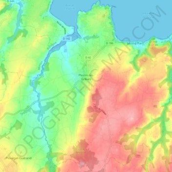
Plestin-les-Grèves topographic map
Interactive map
Click on the map to display elevation.
About this map
Name: Plestin-les-Grèves topographic map, elevation, terrain.
Average elevation: 187 ft
Minimum elevation: 0 ft
Maximum elevation: 433 ft
Other topographic maps
Click on a map to view its topography, its elevation and its terrain.
Coat Carric
France > Brittany > Côtes-d'Armor > Plestin-les-Grèves
Coat Carric, Plestin-les-Grèves, Lannion, Côtes-d'Armor, Brittany, Metropolitan France, 22310, France
Average elevation: 174 ft