
Borujerd City topographic map
Interactive map
Click on the map to display elevation.
About this map
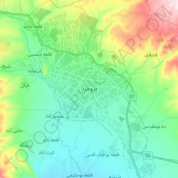
Name: Borujerd City topographic map, elevation, terrain.
Average elevation: 5,318 ft
Minimum elevation: 4,921 ft
Maximum elevation: 6,440 ft
Borujerd city is located approximately 1670 meters above sea level and has a moderate climate with cold winters. The highest point is Garrin Mountain 3623 m above sea level and the lowest area is Gelerood River in South with 1400 m elevation. Borujerd Township has 2600 km2 area with approximately 400,000 inhabitants distributed in the city of Oshtorinan and more than 180 villages. Owing to favorable topographic and climatic conditions, the plains are devoted to cultivation of grain. Wherever irrigation is possible (by means of qanāts, wells, diversion of water of streams), cotton, melons, grapes, and fruit trees (especially almonds) are grown.
Other topographic maps
Click on a map to view its topography, its elevation and its terrain.
Maru
Iran > Lorestan Province > Borujerd County
Maru, Central District, Borujerd County, Lorestan Province, Iran
Average elevation: 7,359 ft