
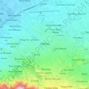
Delmas, Ouest topographic map
Interactive map
Click on the map to display elevation.
About this map
Name: Delmas, Ouest topographic map, elevation, terrain.
Location: Delmas, Ouest, Port-au-Prince, West, Haiti (18.52213 -72.33860 18.58037 -72.25662)
Average elevation: 430 ft
Minimum elevation: 16 ft
Maximum elevation: 2,247 ft
Other topographic maps
Click on a map to view its topography, its elevation and its terrain.
Sisal
Haiti > West > Commune Arcahaie > Williamson
Sisal, 4e-Montrouis, Williamson, Commune Arcahaie, Arrondissement de l’Arcahaie, West, Haiti
Average elevation: 653 ft
Port-au-Prince
Haiti > West > Port-au-Prince
Port-au-Prince, West, BP98, Haiti
Average elevation: 1,234 ft
Pic la Selle
Haiti > West > Commune Croix-des-Bouquets
Pic la Selle, Commune Croix-des-Bouquets, Arrondissement de Croix-des-Bouquets, West, Haiti
Average elevation: 7,756 ft
Faults
Haiti > West > Commune Thomazeau
Faults, Commune Thomazeau, Arrondissement de Croix-des-Bouquets, West, Haiti
Average elevation: 1,486 ft
Petit-Goâve
Haiti > West > Commune Petit-Goâve > Petit-Goâve
Petit-Goâve, Commune Petit-Goâve, Arrondissement de Léogâne, West, HT-6220, Haiti
Average elevation: 328 ft
Vally
Haiti > West > Commune Petit-Goâve
Vally, Commune Petit-Goâve, Arrondissement de Léogâne, West, Haiti
Average elevation: 2,497 ft
Gonâve Island
Gonâve Island, Arrondissement de La Gonâve, West, 6510, Haiti
Average elevation: 177 ft