
Huancavelica topographic map
Interactive map
Click on the map to display elevation.
About this map
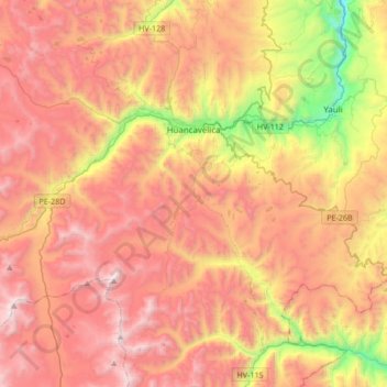
Name: Huancavelica topographic map, elevation, terrain.
Location: Huancavelica, Province of Huancavelica, Huancavelica, Peru (-12.97960 -75.21382 -12.70354 -74.87557)
Average elevation: 14,285 ft
Minimum elevation: 10,584 ft
Maximum elevation: 17,205 ft
The Huancavelica area features a rough geography with highly varied elevation, from 1,950 metres in the valleys to more than 5,000 metres on its snow-covered summits. These mountains contain metallic deposits. They consist of the western chain of the Andes, which includes the Chunta mountain range, formed by a series of hills, the most prominent of which are: Sitaq (5,328m), Wamanrasu (5,298m) and Altar (5,268m).