
Torquay topographic map
Interactive map
Click on the map to display elevation.
About this map
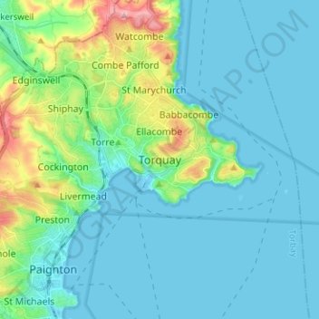
Name: Torquay topographic map, elevation, terrain.
Location: Torquay, Torbay, England, TQ1 1TR, United Kingdom (50.42524 -3.56114 50.50524 -3.48114)
Average elevation: 102 ft
Minimum elevation: -7 ft
Maximum elevation: 584 ft
Other topographic maps
Click on a map to view its topography, its elevation and its terrain.
Fairy Cove
United Kingdom > England > Torbay > Paignton
Fairy Cove, Roundham, Paignton, Torbay, England, United Kingdom
Average elevation: 23 ft