
Gdynia topographic map
Interactive map
Click on the map to display elevation.
About this map
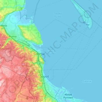
Name: Gdynia topographic map, elevation, terrain.
Location: Gdynia, Pomeranian Voivodeship, Poland (54.42275 18.35798 54.62416 18.90983)
Average elevation: 118 ft
Minimum elevation: -13 ft
Maximum elevation: 715 ft
Other topographic maps
Click on a map to view its topography, its elevation and its terrain.
Klif Orłowski
Poland > Pomeranian Voivodeship > Gdynia
Klif Orłowski, Redłowo, Gdynia, Pomeranian Voivodeship, 81-510, Poland
Average elevation: 56 ft