Geolocate

Ruswil topographic map

Interactive map

Click on the map to display elevation.

About this map

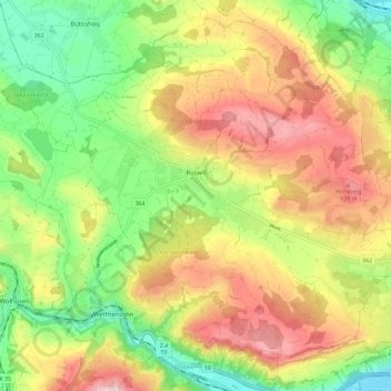
Name: Ruswil topographic map, elevation, terrain.

Location: Ruswil, Lucerne, Switzerland (47.04342 8.08046 47.11513 8.19618)

Average elevation: 2,221 ft

Minimum elevation: 1,614 ft

Maximum elevation: 2,936 ft

Other topographic maps

Click on a map to view its topography, its elevation and its terrain.

Vitznau

Switzerland > Lucerne

Vitznau, Lucerne, 6354, Switzerland

Average elevation: 2,976 ft

Kriens

Switzerland > Lucerne

Kriens, Lucerne, Switzerland

Average elevation: 2,313 ft

Malters

Switzerland > Lucerne

Malters, Lucerne, 6102, Switzerland

Average elevation: 2,293 ft

Weggis

Switzerland > Lucerne

Weggis, Lucerne, Switzerland

Average elevation: 2,136 ft

Honau

Switzerland > Lucerne > Honau

Honau, Lucerne, 6038, Switzerland

Average elevation: 1,545 ft

Horw

Switzerland > Lucerne > Horw

Horw, Lucerne, Switzerland

Average elevation: 2,008 ft

Lucerne

Switzerland > Lucerne

Lucerne, Switzerland

Average elevation: 2,067 ft