
Center Point topographic map
Interactive map
Click on the map to display elevation.
About this map
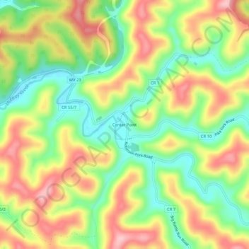
Name: Center Point topographic map, elevation, terrain.
Average elevation: 1,024 ft
Minimum elevation: 751 ft
Maximum elevation: 1,322 ft
Center Point is an unincorporated community in northeastern Doddridge County, West Virginia, United States. It lies along Route 23 northeast of the town of West Union, the county seat of Doddridge County. Its elevation is 791 feet (241 m).
Other topographic maps
Click on a map to view its topography, its elevation and its terrain.
West Union
United States > West Virginia > Doddridge County
West Union, Doddridge County, West Virginia, 26456, United States
Average elevation: 938 ft
New Milton
United States > West Virginia > Doddridge County
New Milton, Doddridge County, West Virginia, 26411, United States
Average elevation: 1,037 ft
Miletus
United States > West Virginia > Doddridge County > Miletus
Miletus, Doddridge County, West Virginia, United States
Average elevation: 1,122 ft