
Ilkley topographic map
Interactive map
Click on the map to display elevation.
About this map
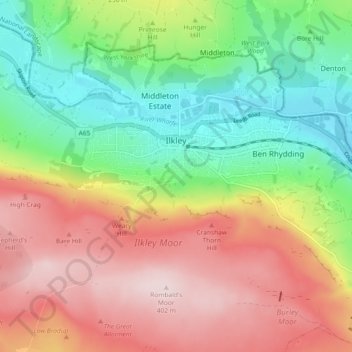
Name: Ilkley topographic map, elevation, terrain.
Location: Ilkley, Bradford, West Yorkshire, England, United Kingdom (53.89957 -1.86948 53.94076 -1.77753)
Average elevation: 725 ft
Minimum elevation: 210 ft
Maximum elevation: 1,319 ft
Other topographic maps
Click on a map to view its topography, its elevation and its terrain.
Bingley
United Kingdom > England > Bradford
Bingley, Bradford, West Yorkshire, England, United Kingdom
Average elevation: 650 ft
Baildon
United Kingdom > England > Bradford > Baildon
Baildon, Bradford, West Yorkshire, England, United Kingdom
Average elevation: 482 ft
Steeton with Eastburn
United Kingdom > England > Bradford
Steeton with Eastburn, Bradford, Yorkshire and the Humber, England, United Kingdom
Average elevation: 597 ft
Middle Brook
United Kingdom > England > Bradford
Middle Brook, Bradford, Yorkshire and the Humber, England, BD8 0ES, United Kingdom
Average elevation: 558 ft