
Neubrandenburg topographic map
Interactive map
Click on the map to display elevation.
About this map
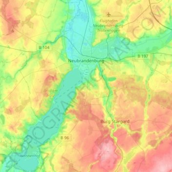
Name: Neubrandenburg topographic map, elevation, terrain.
Average elevation: 190 ft
Minimum elevation: 23 ft
Maximum elevation: 417 ft
Other topographic maps
Click on a map to view its topography, its elevation and its terrain.
Ave
Germany > Mecklenburg-Vorpommern > Mecklenburgische Seenplatte > Penzlin
Ave, Penzlin, Penzliner Land, Mecklenburgische Seenplatte, Mecklenburg-Vorpommern, 17217, Germany
Average elevation: 194 ft
Friedland
Germany > Mecklenburg-Vorpommern > Mecklenburgische Seenplatte
Friedland, Mecklenburgische Seenplatte, Mecklenburg-Vorpommern, Germany
Average elevation: 121 ft
Wildberg
Germany > Mecklenburg-Vorpommern > Mecklenburgische Seenplatte > Wildberg
Wildberg, Treptower Tollensewinkel, Mecklenburgische Seenplatte, Mecklenburg-Vorpommern, Germany
Average elevation: 194 ft
Bartow
Germany > Mecklenburg-Vorpommern > Mecklenburgische Seenplatte > Bartow
Bartow, Treptower Tollensewinkel, Mecklenburgische Seenplatte, Mecklenburg-Vorpommern, Germany
Average elevation: 66 ft
Kieve
Germany > Mecklenburg-Vorpommern > Mecklenburgische Seenplatte > Kieve
Kieve, Röbel-Müritz, Mecklenburgische Seenplatte, Mecklenburg-Vorpommern, Germany
Average elevation: 240 ft
Weisdin
Germany > Mecklenburg-Vorpommern > Mecklenburgische Seenplatte > Blumenholz > Weisdin
Weisdin, Blumenholz, Neustrelitz-Land, Mecklenburgische Seenplatte, Mecklenburg-Vorpommern, 17237, Germany
Average elevation: 253 ft