
Kandy topographic map
Interactive map
Click on the map to display elevation.
About this map
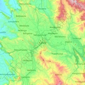
Name: Kandy topographic map, elevation, terrain.
Location: Kandy, Kandy District, Central Province, 20000, Sri Lanka (7.13312 80.47504 7.45312 80.79504)
Average elevation: 2,037 ft
Minimum elevation: 476 ft
Maximum elevation: 6,027 ft
Kandy is located in the mountainous and thickly forested interior of the island. The city is located in between multiple mountain ranges including the Knuckles mountain range and the Hanthana Mountain Range, giving the city an elevation of 500 metres (1,600 ft) above sea level. It lies adjacent to the artificial Kandy Lake and south of Udawatta Kele Sanctuary.Today Udawatte Kele is reducing its area.
Other topographic maps
Click on a map to view its topography, its elevation and its terrain.
Uplands
Sri Lanka > Central Province > Kandy
Uplands, Kandy, Kandy District, Central Province, 20000, Sri Lanka
Average elevation: 1,614 ft
Hantana
Sri Lanka > Central Province > Kandy > Hantana
Hantana, Kandy, Kandy District, Central Province, 85129, Sri Lanka
Average elevation: 2,316 ft
Bogambara
Sri Lanka > Central Province > Kandy > Bogambara
Bogambara, Kandy, Kandy District, Central Province, 20000, Sri Lanka
Average elevation: 1,837 ft