
Petaluma topographic map
Interactive map
Click on the map to display elevation.
About this map
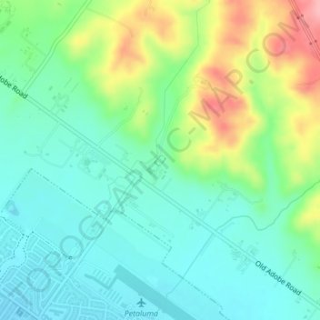
Name: Petaluma topographic map, elevation, terrain.
Location: Petaluma, Sonoma County, California, United States (38.26950 -122.60676 38.27047 -122.60558)
Average elevation: 187 ft
Minimum elevation: 56 ft
Maximum elevation: 479 ft
Other topographic maps
Click on a map to view its topography, its elevation and its terrain.
Petaluma
United States > California > Sonoma County > Petaluma
Petaluma, Sonoma County, California, 94952, United States
Average elevation: 384 ft
Petaluma River
United States > California > Sonoma County > Petaluma
Petaluma River, Petaluma, Sonoma County, California, 94952, United States
Average elevation: 52 ft