
Clipperton Island topographic map
Interactive map
Click on the map to display elevation.
About this map
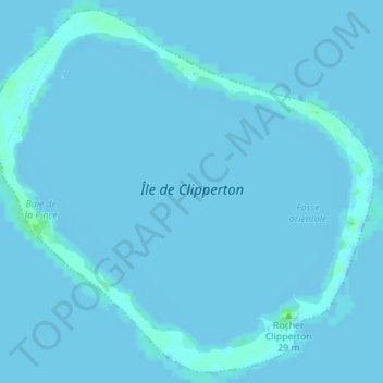
Name: Clipperton Island topographic map, elevation, terrain.
Location: Clipperton Island, France (10.28715 -109.23461 10.31957 -109.19979)
Average elevation: 0 ft
Minimum elevation: -10 ft
Maximum elevation: 23 ft
It is low-lying and largely barren, with some scattered grasses, and a few clumps of coconut palms (Cocos nucifera). Land elevations average 2 m (6.6 ft), though a small volcanic outcrop rising to 29 m (95 ft) on its south-east side is considerably higher and is referred to as 'Clipperton Rock'.[13] The surrounding reef is exposed at low tide.[14] The presence of this rock means that technically Clipperton is not an atoll but an island with a barrier reef.[citation needed]