
Basalt Lake topographic map
Interactive map
Click on the map to display elevation.
About this map
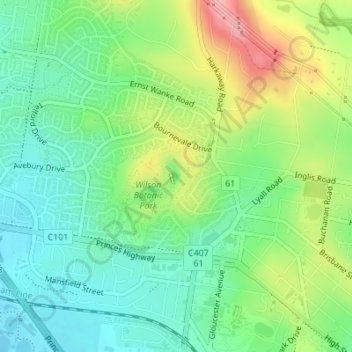
Name: Basalt Lake topographic map, elevation, terrain.
Average elevation: 249 ft
Minimum elevation: 82 ft
Maximum elevation: 561 ft
Other topographic maps
Click on a map to view its topography, its elevation and its terrain.
Narre Warren North District
Australia > Victoria > Harkaway
Narre Warren North District, Hallam Bypass Trail, Fountain Gate, Narre Warren, Harkaway, City of Casey, Victoria, 385, Australia
Average elevation: 197 ft
Timbarra Park
Australia > Victoria > Harkaway
Timbarra Park, Berwick, Harkaway, City of Casey, Victoria, Australia
Average elevation: 220 ft