
Pai topographic map
Interactive map
Click on the map to display elevation.
About this map
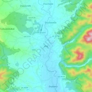
Name: Pai topographic map, elevation, terrain.
Location: Pai, Mae Hong Son Province, 58130, Thailand (19.31811 98.40058 19.39811 98.48058)
Average elevation: 1,985 ft
Minimum elevation: 1,598 ft
Maximum elevation: 3,638 ft
Other topographic maps
Click on a map to view its topography, its elevation and its terrain.
Ban Ja Bo
Thailand > Mae Hong Son Province > Ban Jabo
Ban Ja Bo, 1226, Ban Jabo, Pang Mapha, Mae Hong Son Province, Thailand
Average elevation: 2,907 ft
Mae U Mong Luang
Thailand > Mae Hong Son Province > Soppong
Mae U Mong Luang, Soppong, Pang Mapha, Mae Hong Son Province, Thailand
Average elevation: 2,543 ft
Mae Hong Son Province
Thailand > Mae Hong Son Province
Mae Hong Son Province, Thailand
Average elevation: 1,982 ft