
Pass topographic map
Interactive map
Click on the map to display elevation.
About this map
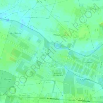
Name: Pass topographic map, elevation, terrain.
Average elevation: 292 ft
Minimum elevation: 272 ft
Maximum elevation: 308 ft
Other topographic maps
Click on a map to view its topography, its elevation and its terrain.
Ożarów Mazowiecki
Poland > Masovian Voivodeship > Warsaw West County > Ożarów Mazowiecki
Ożarów Mazowiecki, gmina Ożarów Mazowiecki, Warsaw West County, Masovian Voivodeship, 05-850, Poland
Average elevation: 322 ft