
Corsicana topographic map
Interactive map
Click on the map to display elevation.
About this map
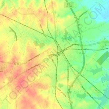
Name: Corsicana topographic map, elevation, terrain.
Location: Corsicana, Navarro, Texas, 75110, United States (32.05130 -96.50468 32.13130 -96.42468)
Average elevation: 423 ft
Minimum elevation: 328 ft
Maximum elevation: 512 ft
Other topographic maps
Click on a map to view its topography, its elevation and its terrain.
Jester Park
United States > Texas > Navarro > Corsicana > Corsicana
Jester Park, Corsicana, Navarro, Texas, United States
Average elevation: 436 ft