
Nanga Parbat topographic map
Interactive map
Click on the map to display elevation.
About this map
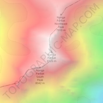
Name: Nanga Parbat topographic map, elevation, terrain.
Average elevation: 23,248 ft
Minimum elevation: 16,998 ft
Maximum elevation: 26,588 ft
To the south, Nanga Parbat has what is often referred to as the highest mountain face in the world: the Rupal Face rises 4,600 m (15,090 ft) above its base. To the north, the complex, somewhat more gently sloped Rakhiot Flank rises 7,000 m (23,000 ft) from the Indus River valley to the summit in just 25 km (16 mi), one of the ten greatest elevation gains in such a short distance on Earth.
Other topographic maps
Click on a map to view its topography, its elevation and its terrain.
Chilum
Pakistan > Gilgit-Baltistan > Astore District
Chilum, Astore District, Diamer-Astore Division, Gilgit-Baltistan, Pakistan
Average elevation: 12,146 ft