
Municipality of Marousi topographic map
Interactive map
Click on the map to display elevation.
About this map
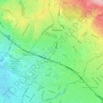
Name: Municipality of Marousi topographic map, elevation, terrain.
Average elevation: 735 ft
Minimum elevation: 489 ft
Maximum elevation: 1,165 ft
Other topographic maps
Click on a map to view its topography, its elevation and its terrain.
Municipality of Kifisia
Greece > Attica > Regional Unit of North Athens
Municipality of Kifisia, Regional Unit of North Athens, Attica, Greece
Average elevation: 1,122 ft