
Nettetal topographic map
Interactive map
Click on the map to display elevation.
About this map
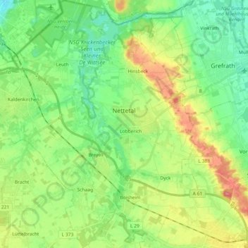
Name: Nettetal topographic map, elevation, terrain.
Location: Nettetal, Kreis Viersen, North Rhine-Westphalia, 41334, Germany (51.25277 6.15382 51.36594 6.32656)
Average elevation: 167 ft
Minimum elevation: 75 ft
Maximum elevation: 331 ft
Other topographic maps
Click on a map to view its topography, its elevation and its terrain.
Viersen
Germany > North Rhine-Westphalia > Kreis Viersen
Viersen, Kreis Viersen, North Rhine-Westphalia, Germany
Average elevation: 167 ft
Brüggen
Germany > North Rhine-Westphalia > Kreis Viersen
Brüggen, Kreis Viersen, North Rhine-Westphalia, 41379, Germany
Average elevation: 161 ft