
Skellefteå topographic map
Interactive map
Click on the map to display elevation.
About this map
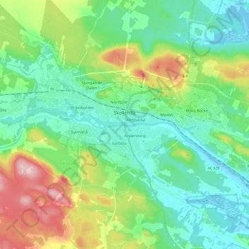
Name: Skellefteå topographic map, elevation, terrain.
Location: Skellefteå, Skellefteå kommun, Västerbotten County, Sweden (64.71455 20.87541 64.77977 21.10801)
Average elevation: 161 ft
Minimum elevation: -16 ft
Maximum elevation: 561 ft
Other topographic maps
Click on a map to view its topography, its elevation and its terrain.
Lycksele kommun
Lycksele kommun, Västerbotten County, Sweden
Average elevation: 1,168 ft
Storumans kommun
Storumans kommun, Västerbotten County, Sweden
Average elevation: 1,929 ft