
Mürzzuschlag topographic map
Interactive map
Click on the map to display elevation.
About this map
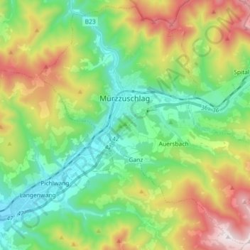
Name: Mürzzuschlag topographic map, elevation, terrain.
Location: Mürzzuschlag, Bezirk Bruck-Mürzzuschlag, Styria, 8680, Austria (47.54884 15.62623 47.64103 15.76979)
Average elevation: 3,212 ft
Minimum elevation: 2,047 ft
Maximum elevation: 5,463 ft
Other topographic maps
Click on a map to view its topography, its elevation and its terrain.
Gemeinde Spital am Semmering
Austria > Styria > Bezirk Bruck-Mürzzuschlag
Gemeinde Spital am Semmering, Bezirk Bruck-Mürzzuschlag, Styria, 8684, Austria
Average elevation: 3,799 ft
Bruck an der Mur
Austria > Styria > Bezirk Bruck-Mürzzuschlag
Bruck an der Mur, Bezirk Bruck-Mürzzuschlag, Styria, 8600, Austria
Average elevation: 2,713 ft
Mariazell
Austria > Styria > Bezirk Bruck-Mürzzuschlag > Mariazell
Mariazell, Bezirk Bruck-Mürzzuschlag, Styria, 8630, Austria
Average elevation: 3,688 ft