
Germersheim topographic map
Interactive map
Click on the map to display elevation.
About this map
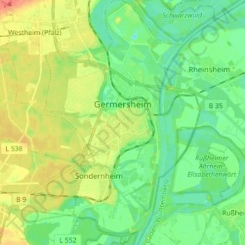
Name: Germersheim topographic map, elevation, terrain.
Average elevation: 341 ft
Minimum elevation: 285 ft
Maximum elevation: 430 ft
Other topographic maps
Click on a map to view its topography, its elevation and its terrain.
Wörth am Rhein
Germany > Rhineland-Palatinate > Landkreis Germersheim
Wörth am Rhein, Landkreis Germersheim, Rhineland-Palatinate, 76744, Germany
Average elevation: 377 ft
Knittelsheim
Germany > Rhineland-Palatinate > Landkreis Germersheim > Knittelsheim
Knittelsheim, Bellheim, Landkreis Germersheim, Rhineland-Palatinate, Germany
Average elevation: 410 ft