
Mount Pico topographic map
Interactive map
Click on the map to display elevation.
About this map
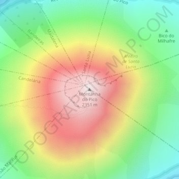
Name: Mount Pico topographic map, elevation, terrain.
Location: Mount Pico, Madalena, Pico, Azores, 9950-422, Portugal (38.46867 -28.39933 38.46877 -28.39923)
Average elevation: 5,558 ft
Minimum elevation: 3,865 ft
Maximum elevation: 7,598 ft
Mount Pico (Portuguese: Montanha do Pico) is a stratovolcano located on Pico Island, in the mid-Atlantic archipelago of the Azores. It is the highest mountain of Portugal, at 2,351 metres (7,713 ft) above sea level, and is one of the highest Atlantic mountains; it is more than twice the elevation of any other peak in the Azores.