
Torre de Moncorvo topographic map
Interactive map
Click on the map to display elevation.
About this map
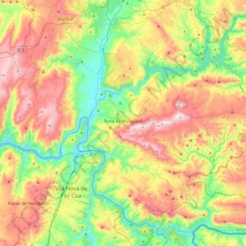
Name: Torre de Moncorvo topographic map, elevation, terrain.
Location: Torre de Moncorvo, Bragança, Portugal (41.03308 -7.22371 41.30919 -6.79818)
Average elevation: 1,444 ft
Minimum elevation: 338 ft
Maximum elevation: 2,979 ft
Torre de Moncorvo has a Mediterranean climate with warm to very hot, dry summers and cool, wet winters, depending on the altitude.
Other topographic maps
Click on a map to view its topography, its elevation and its terrain.
Foz do Tua
Portugal > Bragança > Carrazeda de Ansiães
Foz do Tua, Castanheiro do Norte e Ribalonga, Carrazeda de Ansiães, Bragança, Portugal
Average elevation: 915 ft
San Miguel
San Miguel, Caçarelhos e Angueira, Vimioso, Bragança, Portugal
Average elevation: 2,382 ft
Quintanilha
Portugal > Bragança > Bragança
Quintanilha, Bragança, 5300-771, Portugal
Average elevation: 2,178 ft