
St. Peter topographic map
Interactive map
Click on the map to display elevation.
About this map
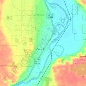
Name: St. Peter topographic map, elevation, terrain.
Location: St. Peter, Nicollet County, Minnesota, 56082, United States (44.29745 -93.98977 44.35864 -93.93336)
Average elevation: 856 ft
Minimum elevation: 728 ft
Maximum elevation: 1,066 ft
Other topographic maps
Click on a map to view its topography, its elevation and its terrain.
North Mankato
United States > Minnesota > Nicollet County
North Mankato, Nicollet County, Minnesota, 56003, United States
Average elevation: 902 ft
Courtland
United States > Minnesota > Nicollet County
Courtland, Nicollet County, Minnesota, 56021, United States
Average elevation: 922 ft