
Bingham topographic map
Interactive map
Click on the map to display elevation.
About this map
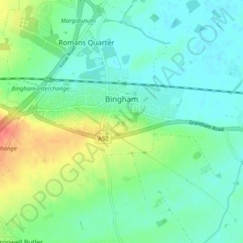
Name: Bingham topographic map, elevation, terrain.
Location: Bingham, Rushcliffe, Nottinghamshire, England, United Kingdom (52.92835 -0.98581 52.96686 -0.91605)
Average elevation: 108 ft
Minimum elevation: 59 ft
Maximum elevation: 226 ft
Other topographic maps
Click on a map to view its topography, its elevation and its terrain.
Tollerton
United Kingdom > England > Nottinghamshire > Rushcliffe
Tollerton, Rushcliffe, Nottinghamshire, England, United Kingdom
Average elevation: 128 ft
Cotgrave
United Kingdom > England > Nottinghamshire > Rushcliffe
Cotgrave, Rushcliffe, Nottinghamshire, East Midlands, England, United Kingdom
Average elevation: 177 ft