
Medicine Bow Peak topographic map
Interactive map
Click on the map to display elevation.
About this map
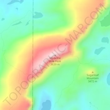
Name: Medicine Bow Peak topographic map, elevation, terrain.
Location: Medicine Bow Peak, Albany County, Wyoming, United States (41.36020 -106.31734 41.36030 -106.31724)
Average elevation: 11,142 ft
Minimum elevation: 10,607 ft
Maximum elevation: 11,991 ft
Medicine Bow Peak (12,018 ft (3,663 m)) is the highest peak in the Snowy Range, a part of the Medicine Bow Mountains, about 35 miles (56 km) west of Laramie, Wyoming. It lies within Medicine Bow National Forest and is the highest point in southern Wyoming. The summit lies in extreme western Albany County, but the mountain's lower reaches stretch westward into eastern Carbon County. The summit is 12,018 feet (3,663 m) high and is visible from Snowy Range Pass, elevation 10,847 ft (3,300 m), on Wyoming Highway 130, a Wyoming Scenic Byway. The most commonly used trail to the peak is a four-mile hike featuring switch-backs and a great deal of loose rock. The trails to the peak are usually open from early June to mid October.
Other topographic maps
Click on a map to view its topography, its elevation and its terrain.
Jelm Mountain
United States > Wyoming > Albany County
Jelm Mountain, Albany County, Wyoming, 82063, United States
Average elevation: 8,727 ft
Laramie
United States > Wyoming > Albany County
Laramie, Albany County, Wyoming, United States
Average elevation: 7,280 ft
Laramie
United States > Wyoming > Albany County
Laramie, Albany County, Wyoming, United States
Average elevation: 7,280 ft
Centennial
United States > Wyoming > Albany County
Centennial, Albany County, Wyoming, 82055, United States
Average elevation: 8,455 ft
Jelm
United States > Wyoming > Albany County
Jelm, Albany County, Wyoming, United States
Average elevation: 7,946 ft
PhinDeli Town Buford
United States > Wyoming > Albany County
PhinDeli Town Buford, Albany County, Wyoming, United States
Average elevation: 7,828 ft
North Twin Lakes
United States > Wyoming > Albany County
North Twin Lakes, Albany County, Wyoming, United States
Average elevation: 10,689 ft
Black Mountain
United States > Wyoming > Albany County
Black Mountain, Albany County, Wyoming, United States
Average elevation: 7,126 ft
Laramie
United States > Wyoming > Albany County > Laramie
Laramie, Albany County, Wyoming, 82070, United States
Average elevation: 7,543 ft