
Maroochydore topographic map
Interactive map
Click on the map to display elevation.
About this map
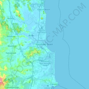
Name: Maroochydore topographic map, elevation, terrain.
Location: Maroochydore, Queensland, 4558, Australia (-26.81565 152.93467 -26.49565 153.25467)
Average elevation: 66 ft
Minimum elevation: -7 ft
Maximum elevation: 1,496 ft
Other topographic maps
Click on a map to view its topography, its elevation and its terrain.
Eudlo Creek
Australia > Queensland > Maroochydore
Eudlo Creek, Diddillibah, Maroochydore, Sunshine Coast Regional, Queensland, 4558, Australia
Average elevation: 23 ft
Kondalilla National Park
Australia > Queensland > Maroochydore
Kondalilla National Park, Shultz Road, Maroochydore, Queensland, Australia
Average elevation: 948 ft