
The Municipal District of Birr topographic map
Interactive map
Click on the map to display elevation.
About this map
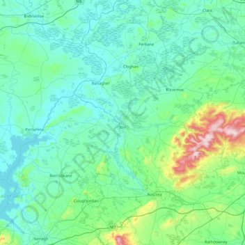
Name: The Municipal District of Birr topographic map, elevation, terrain.
Average elevation: 318 ft
Minimum elevation: 89 ft
Maximum elevation: 1,693 ft
Other topographic maps
Click on a map to view its topography, its elevation and its terrain.
Horseleap
Horseleap, The Municipal District of Tullamore, County Offaly, Leinster, Ireland
Average elevation: 230 ft
Clara
Clara, Clara ED, The Municipal District of Tullamore, County Offaly, Leinster, Ireland
Average elevation: 203 ft
Wood
Wood, Ballyburly ED, The Municipal District of Edenderry, County Offaly, Leinster, Ireland
Average elevation: 246 ft
Shane Valley
Shane Valley, Edenderry Rural ED, The Municipal District of Edenderry, County Offaly, Leinster, R45 X951, Ireland
Average elevation: 233 ft
Down
Down, Mountbriscoe ED, The Municipal District of Edenderry, County Offaly, Leinster, Ireland
Average elevation: 289 ft