
Uzundere topographic map
Interactive map
Click on the map to display elevation.
About this map
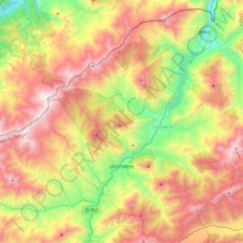
Name: Uzundere topographic map, elevation, terrain.
Location: Uzundere, Erzurum, Eastern Anatolia Region, Turkey (40.47016 41.40981 40.69218 41.75883)
Average elevation: 5,955 ft
Minimum elevation: 2,402 ft
Maximum elevation: 10,069 ft
Other topographic maps
Click on a map to view its topography, its elevation and its terrain.
Uzundere Mahallesi
Uzundere Mahallesi, Uzundere, Erzurum, Eastern Anatolia Region, Turkey
Average elevation: 4,518 ft