
Glacier Cook topographic map
Interactive map
Click on the map to display elevation.
About this map
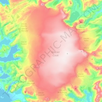
Name: Glacier Cook topographic map, elevation, terrain.
Average elevation: 1,667 ft
Minimum elevation: -16 ft
Maximum elevation: 3,409 ft
Other topographic maps
Click on a map to view its topography, its elevation and its terrain.
Le Phare
France, Terres australes et antarctiques françaises, Îles Kerguelen (eaux territoriales)
Le Phare, Kerguelen Archipelago, France, Terres australes et antarctiques françaises, Îles Kerguelen (eaux territoriales)
Average elevation: 1,368 ft
Ratmanoff
France, Terres australes et antarctiques françaises, Îles Kerguelen (eaux territoriales) > French Southern and Antarctic Lands > Ratmanoff
Ratmanoff, Kerguelen Archipelago, French Southern and Antarctic Lands, France, Terres australes et antarctiques françaises, Îles Kerguelen (eaux territoriales)
Average elevation: 20 ft