
Oranienburg topographic map
Interactive map
Click on the map to display elevation.
About this map
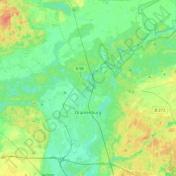
Name: Oranienburg topographic map, elevation, terrain.
Location: Oranienburg, Oberhavel, Brandenburg, 16515, Germany (52.70939 13.13096 52.84647 13.43060)
Average elevation: 141 ft
Minimum elevation: 95 ft
Maximum elevation: 249 ft
Other topographic maps
Click on a map to view its topography, its elevation and its terrain.
Sonnenberg
Germany > Brandenburg > Oberhavel
Sonnenberg, Gransee und Gemeinden, Oberhavel, Brandenburg, Germany
Average elevation: 200 ft