
Khamis Mushayt topographic map
Interactive map
Click on the map to display elevation.
About this map
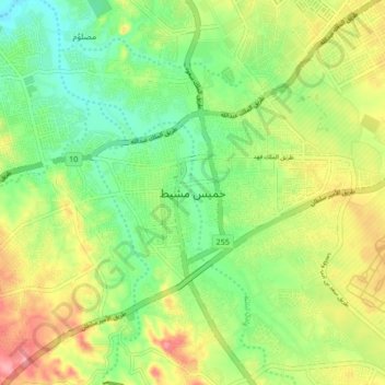
Name: Khamis Mushayt topographic map, elevation, terrain.
Location: Khamis Mushayt, 'Asir Province, 62411, Saudi Arabia (18.14000 42.57333 18.46000 42.89333)
Average elevation: 6,719 ft
Minimum elevation: 4,902 ft
Maximum elevation: 7,782 ft
Khamis Mushait has a semi-arid climate (Köppen climate classification BSk), although its high altitude of 2,066 metres or 6,780 feet makes it less extreme than most of Arabia. For instance, Riyadh is around 7.4 °C or 13.3 °F hotter on average throughout the year, despite being about 670 kilometres or 420 miles further from the equator.
Other topographic maps
Click on a map to view its topography, its elevation and its terrain.
الصبيخة
الصبيخة, Tarib, 'Asir Province, Saudi Arabia
Average elevation: 4,485 ft
Muhayil
Muhayil, 'Asir Province, Saudi Arabia
Average elevation: 1,818 ft
Tanumah
Tanumah, 'Asir Province, Saudi Arabia
Average elevation: 7,438 ft
Tanumah
Tanumah, 'Asir Province, Saudi Arabia
Average elevation: 5,604 ft
An Nimas
An Nimas, 'Asir Province, Saudi Arabia
Average elevation: 6,037 ft
Abha
Abha, 'Asir Province, 26442, Saudi Arabia
Average elevation: 6,542 ft