
Marsala topographic map
Interactive map
Click on the map to display elevation.
About this map
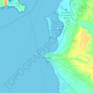
Name: Marsala topographic map, elevation, terrain.
Location: Marsala, Trapani, Sicily, 91025, Italy (37.71390 12.42425 37.93445 12.69461)
Average elevation: 72 ft
Minimum elevation: -7 ft
Maximum elevation: 951 ft
The archaeological area of Marsala has been investigated both through excavations and topographic studies. Lilybaeum, the ancient town, took up a rectangular area on Capo Boeo, a low and rocky promontory sloping gently down towards the sea. The urban layout of the town can be dated back to the 2nd century BC, taking the shape of a Roman camp, with modern-day Viale Vittorio Veneto the Decumanus Maximus and Viale Cesare Battisti the Cardo Maximus. In 350 BC the newly formed town of Marsala was surrounded by town walls and a deep moat, however the moat has long been buried. Little remains of Lilybaeum today, however several fragments of the city walls and ancient foundations are still visible. Excavations took place in 2005 on Via Giuseppe Garraffa near the town center, revealing Roman foundations. The Baglio Anselmi Archaeological Museum houses an example of Carthaginian ship used during the Battle of the Aegates Islands (241 BC) found on the seabed off the coast of Marsala, as well as other ancient remains from the area, such as pottery, marble sculptures and mosaics.