
Belen topographic map
Interactive map
Click on the map to display elevation.
About this map
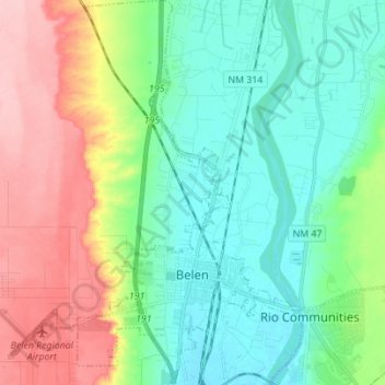
Name: Belen topographic map, elevation, terrain.
Location: Belen, Valencia County, New Mexico, United States (34.63024 -106.84249 34.74404 -106.73938)
Average elevation: 4,948 ft
Minimum elevation: 4,790 ft
Maximum elevation: 5,266 ft
Other topographic maps
Click on a map to view its topography, its elevation and its terrain.
Los Chaves
United States > New Mexico > Valencia County
Los Chaves, Valencia County, New Mexico, United States
Average elevation: 4,869 ft
Bosque Farms
United States > New Mexico > Valencia County
Bosque Farms, Valencia County, New Mexico, 87068, United States
Average elevation: 4,872 ft
Los Lunas
United States > New Mexico > Valencia County
Los Lunas, Valencia County, New Mexico, 87031, United States
Average elevation: 5,095 ft