
Fez topographic map
Interactive map
Click on the map to display elevation.
About this map
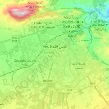
Name: Fez topographic map, elevation, terrain.
Average elevation: 1,417 ft
Minimum elevation: 696 ft
Maximum elevation: 2,730 ft
The last major change to Fez's topography before the 20th century was made during the reign of Moulay Hassan I (1873-1894), who finally connected Fes Jdid and Fes el-Bali by building a walled corridor between them. New gardens and summer palaces, used by the royals and the capital's high society, were built within the corridor, such as the Jnan Sbil Gardens and the Dar Batha palace. Moulay Hassan also expanded the old Royal Palace itself, extending its entrance up to the current location of the Old Mechouar while adding the New Mechouar, along with the Dar al-Makina, to the north. The expansion separated the Moulay Abdallah neighbourhood to the northwest from the rest of Fes Jdid.
Other topographic maps
Click on a map to view its topography, its elevation and its terrain.
Fez
Morocco > Pachalik du Fes باشوية فاس > Fez
Fez, Pachalik du Fes باشوية فاس, Fez Prefecture, Fez-Meknes, 30030, Morocco
Average elevation: 1,447 ft
Borj Sud
Morocco > Pachalik du Fes باشوية فاس > arrondissement de Jnan El Ouard جنان الورد
Borj Sud, Boulevard Allal El Fassi, Oued Zitoun, Fès-Médina, arrondissement de Jnan El Ouard جنان الورد, Pachalik du Fes باشوية فاس, Fez Prefecture, Fez-Meknes, 30200, Morocco
Average elevation: 1,161 ft