
Playa La Herradura topographic map
Interactive map
Click on the map to display elevation.
About this map
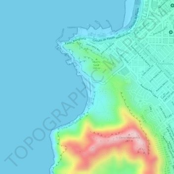
Name: Playa La Herradura topographic map, elevation, terrain.
Average elevation: 171 ft
Minimum elevation: -3 ft
Maximum elevation: 922 ft
Other topographic maps
Click on a map to view its topography, its elevation and its terrain.
Morro Solar
Peru > Lima > Chorrillos
Morro Solar, Chorrillos, Province of Lima, Lima Metropolitan Area, Lima, 15064, Peru
Average elevation: 125 ft