
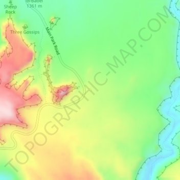
La Sal Mountains Viewpoint topographic map
Interactive map
Click on the map to display elevation.
About this map
Name: La Sal Mountains Viewpoint topographic map, elevation, terrain.
Average elevation: 4,419 ft
Minimum elevation: 3,993 ft
Maximum elevation: 4,993 ft
Other topographic maps
Click on a map to view its topography, its elevation and its terrain.
Moab
United States > Utah > Grand County
Moab, Grand County, Utah, 84532, United States
Average elevation: 4,452 ft
Westwater
United States > Utah > Grand County
Westwater, Grand County, Utah, United States
Average elevation: 4,426 ft
Cisco
United States > Utah > Grand County
Cisco, Grand County, Utah, 84515, United States
Average elevation: 4,377 ft
Rectory
United States > Utah > Grand County
Rectory, Grand County, Utah, United States
Average elevation: 5,010 ft
Delicate Arch
United States > Utah > Grand County
Delicate Arch, Delicate Arch Trail, Grand County, Utah, United States
Average elevation: 4,623 ft
Thompson Springs
United States > Utah > Grand County
Thompson Springs, Grand County, Utah, 84540, United States
Average elevation: 5,194 ft
Arches National Park
United States > Utah > Grand County
Arches National Park, Grand County, Utah, United States
Average elevation: 4,843 ft
Colorado River
United States > Utah > Grand County > Moab
Colorado River, Moab, Grand County, Utah, United States
Average elevation: 5,472 ft
Castle Valley
United States > Utah > Grand County
Castle Valley, Grand County, Utah, United States
Average elevation: 5,282 ft
Cottonwood Point
United States > Utah > Grand County
Cottonwood Point, Grand County, Utah, United States
Average elevation: 7,697 ft