
District I topographic map
Interactive map
Click on the map to display elevation.
About this map
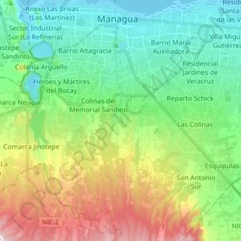
Name: District I topographic map, elevation, terrain.
Location: District I, Managua, Nicaragua (12.03337 -86.29123 12.16425 -86.23518)
Average elevation: 833 ft
Minimum elevation: 128 ft
Maximum elevation: 2,369 ft
Other topographic maps
Click on a map to view its topography, its elevation and its terrain.
Distrito III
Distrito III, Managua, Nicaragua
Average elevation: 1,010 ft
Distrito II
Distrito II, Managua, 12000, Nicaragua
Average elevation: 269 ft