
Guernsey topographic map
Interactive map
Click on the map to display elevation.
About this map
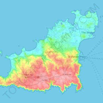
Name: Guernsey topographic map, elevation, terrain.
Location: Guernsey, Castel, Guernsey (49.41553 -2.67517 49.50908 -2.50181)
Average elevation: 59 ft
Minimum elevation: -20 ft
Maximum elevation: 344 ft
Situated in Mont Saint-Michel Bay at around 49°35′N 2°20′W / 49.583°N 2.333°W / 49.583; -2.333, Guernsey, Herm and some other smaller islands together have a total area of 71 square kilometres (27 sq mi) and coastlines of about 46 kilometres (29 mi). Elevation varies from sea level to 110 m (360 ft) at Hautnez on Guernsey.