
Homestead topographic map
Interactive map
Click on the map to display elevation.
About this map
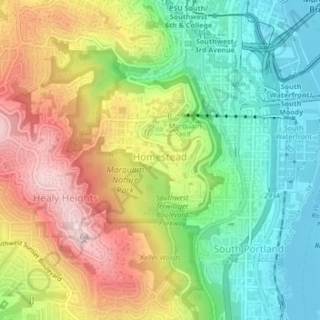
Name: Homestead topographic map, elevation, terrain.
Location: Homestead, Portland, Multnomah County, Oregon, USA (45.48552 -122.69838 45.50594 -122.67686)
Average elevation: 449 ft
Minimum elevation: 7 ft
Maximum elevation: 1,047 ft
Other topographic maps
Click on a map to view its topography, its elevation and its terrain.
Eastmoreland
Eastmoreland, Portland, Multnomah County, Oregon, 97202, USA
Average elevation: 138 ft
Hoyt Arboretum
Hoyt Arboretum, Arlington Heights, Portland, Multnomah County, Oregon, USA
Average elevation: 686 ft
Powell Butte Nature Park
Powell Butte Nature Park, Pleasant Valley, Portland, Multnomah County, Oregon, USA
Average elevation: 404 ft
Northwest District
Northwest District, Portland, Multnomah County, Oregon, 97210, USA
Average elevation: 171 ft
Hosford-Abernethy
Hosford-Abernethy, Portland, Multnomah County, Oregon, USA
Average elevation: 85 ft
Oaks Bottom Wildlife Refuge
Oaks Bottom Wildlife Refuge, Westmoreland, Sellwood-Moreland, Portland, Multnomah County, Oregon, USA
Average elevation: 56 ft