
Zona Austral topographic map
Interactive map
Click on the map to display elevation.
About this map
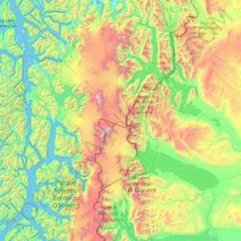
Name: Zona Austral topographic map, elevation, terrain.
Average elevation: 2,520 ft
Minimum elevation: -3 ft
Maximum elevation: 11,634 ft
In the far south (Chile Austral), which extends from Valdivia through the Chacao Channel to Cape Horn, the Andes and the South Pacific meet. This district of the country is mountainous, heavily forested and inhospitable. The deeply indented coastline is filled with islands which preserve the general outline of the continent southward to the Fuegian archipelago, the outside groups forming a continuation of the Chilean Coast Range. The heavy and continuous rainfall throughout this region, especially in the latitude of Chiloé, gives rise to a large number of rivers and lakes. Farther south this excessive precipitation is in the form of snow in the Andes, forming glaciers at a comparatively low level which in places discharge into the inlets and bays of the sea. The extreme southern part of this region extends eastward to the Atlantic entrance to the Strait of Magellan, and includes the greater part of the Isla Grande de Tierra del Fuego with all the islands lying south and west of it. There are some comparatively level stretches of country immediately north of the Strait, partly forested and partly grassy plains, where sheep farming has been established with some degree of success, but the greater part of this extreme southern territory is mountainous, cold, wet and inhospitable. The perpetual snow-line here descends to 1,000 to 1,200 m (3,500 to 4,000 ft) above sea-level, and the forest growth does not rise above an altitude of 300 to 450 m (1,000 to 1,500 ft).