
Casale Monferrato topographic map
Interactive map
Click on the map to display elevation.
About this map
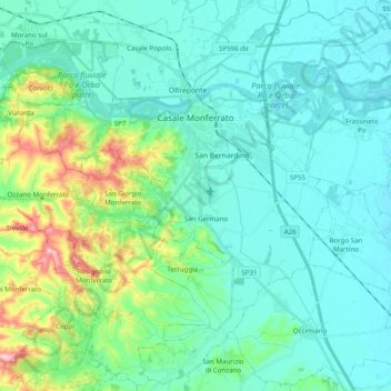
Name: Casale Monferrato topographic map, elevation, terrain.
Location: Casale Monferrato, Alessandria, Piedmont, 15033, Italy (45.04102 8.35945 45.17566 8.55704)
Average elevation: 466 ft
Minimum elevation: 318 ft
Maximum elevation: 1,109 ft
At the south-east corner of the piazza is the elegant Baroque church of Santa Maria delle Grazie, better known by its earlier designation of Santa Caterina. A master-work of Giovanni Battista Scapitta, completed after his death by Giacomo Zanetti, it is marked by an elliptical cupola, and a façade curvilinear both in plan and elevation.
Other topographic maps
Click on a map to view its topography, its elevation and its terrain.
Silver poplar
Italy > Piedmont > Alessandria > Castelnuovo Scrivia > Il Secco
Silver poplar, Strada Secco, Il Secco, Castelnuovo Scrivia, Alessandria, Piedmont, 15053, Italy
Average elevation: 259 ft
Isola Sant'Antonio
Italy > Piedmont > Alessandria
Isola Sant'Antonio, Alessandria, Piedmont, Italy
Average elevation: 249 ft
Incisa
Italy > Piedmont > Alessandria > Montacuto
Incisa, Montacuto, Alessandria, Piedmont, 15056, Italy
Average elevation: 1,749 ft
Masio
Italy > Piedmont > Alessandria
Masio, Alessandria, Piedmont, 15024, Italy
Average elevation: 423 ft
Serravalle Scrivia
Italy > Piedmont > Alessandria
Serravalle Scrivia, Alessandria, Piedmont, 15069, Italy
Average elevation: 860 ft
Sale
Italy > Piedmont > Alessandria
Sale, Alessandria, Piedmont, 15045, Italy
Average elevation: 289 ft